

Unmanned Aerial Systems (UAS), or drones, have proved to be a useful tool for PennDOT. Drones are used to remotely view areas which are not accessible by foot, that provide a safety hazard to personnel, or where a "bird's eye view" is needed. The Bureau of Construction and Materials, Central Office Geotechnical Section has used drones since 2012 to view and monitor sinkholes, land/rockslides, and to provide an overview of highway projects and bridge construction.
PennDOT requires an operator and spotter for drone flights. PennDOT's Bureau of Aviation requires both the drone operator and spotter to obtain a UAS pilot license from the FAA. The operator is to submit an AV-14 Form, which explains the flight location and conditions, to their UAS Coordinator. Approval for the flight must be obtained in advance of the drone flight, and when the drone is in flight the operator must always keep the drone within their line of site. The drone is not authorized to be flown over traffic or people, and flight is not recommended when precipitation and strong winds are forecast. CO Geotech's UAS system has greatly increased capability to assist districts, while improving the safety of field views when used as approved and under correct conditions.
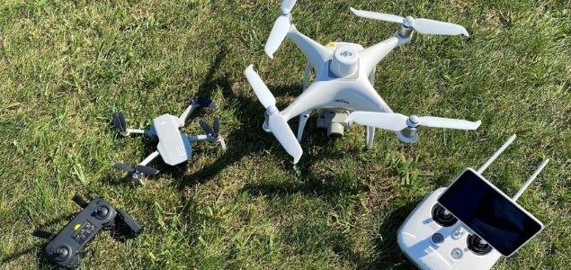
CO Geotech currently uses the DJI Phantom 4 RTK and the DJI Mavic Mini drones. Both drones can fly approximately 30 minutes on a fully charged battery; with up to 2.5 hours of flight time using backup batteries. The operator uses the drone's camera to take high resolution photos and videos. Stabilizing systems in the drone keep the images clear and stable, even in a moderate wind. The drone's "home" function can be used to automatically return the drone to its takeoff location at any point during the flight to facilitate a safe landing.
As UAS is an emerging technology, CO Geotech coordinates with the FAA, as well as PennDOT's Bureau of Aviation, and Photogrammetry and Surveying Section to ensure FAA and PennDOT UAS requirements and regulations are followed. CO Geotech also provides feedback to these agencies to assure useful results, and safe and efficient UAS operation.
For further information on CO Geotech's drone, or for more information on drone use for geotechnical applications, please contact the Central Office Geotechnical Section.
ABOUT THIS BLOG
Did you know PennDOT is directly responsible for nearly 40,000 miles of highway and roughly 25,000 bridges? We oversee programs and policies affecting highways, urban and rural public transportation, airports, railroads, ports and waterways, in addition to administering the state's more than 11 million vehicle registrations and 8.8 million driver's licenses.
So, how do we do what we do? And how can we help you travel in Pennsylvania — whether it be for business or leisure — in safe and enjoyable manner? Read PennDOT Way to learn more about the department, what we do, and how and why we do it.
TAGS
50-Year Anniversary, 511PA, Aggressive Driving, Airports, Autonomous Vehicles, Bicycles, Bridges, Child Safety, Community Relations, Construction, COVID-19, Distracted Driving, District 1, District 10, District 11, District 12, District 2, District 3, District 4, District 5, District 6, District 8, District 9, DOTcom, Driver and Vehicle Services, Emergency Responders, Employment, Equity, FAQ Friday, Human Trafficking, Impaired Driving, Innovations, Live Free Ride Alive, Maintenance Monday, Motorcycles, Older Drivers, PA Motorcycle Safety Program, Pedestrians, PennDOT Connects, Ports, Public Transit, Railroads, REAL ID, Road MaP, Roadside Beautification, Rural Roads, Safety, School Buses, Seat Belts, State Transportation Innovation Council (STIC), Sustainability, Teen Drivers, Throwback Thursday, Transportation Funding, Travel in PA, Welcome Centers, Winter, Work Smart, Work Zone, Yellow Dot
LATEST POSTS
PennDOT Continues Sharing, Updating Resources for Local Governments to Pursue Bipartisan Infrastructure Law Funding Opportunities
Norwin High School Wins 2024 ‘Innovations Challenge’
Demo Complete: I-95 CAP Project in Center City Philadelphia
PennDOT Archeologist Connects Past, Present, and Future
Lehigh Valley DUI, Highway Safety Task Force Hosts Law Enforcement Seminar
ARCHIVES
2024
2023
2022
2021
2020
2019
2018
2017